

admin admin
The sudden nature of earthquakes creates an immediate information gap that often disrupts rescue operations and complicates disaster management. Ground reports are often limited due to damaged infrastructure, disrupted communications, and limited access to affected zones. As a result, rapid, effective decision-making becomes difficult for officials, raising the risk of misallocation and delays.
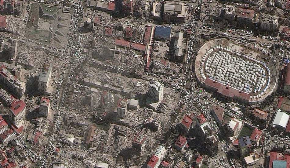
Earth observation imagery can bridge the information gap by delivering near-real-time situational awareness across large impacted areas. Spatial data enables field teams to quickly identify high-impact zones, urban versus rural impact patterns, blocked transport corridors, and potential secondary risks, all of which are crucial for strategic planning. In such circumstances, response coordination becomes more efficient using a single platform for sourcing and comparing multi-provider imagery.
To distinguish earthquake damage from pre-existing conditions, analysts rely on pre-event imagery as a baseline. High-resolution reference imagery captured prior to the earthquake establishes a reliable reference for normal urban layouts, building footprints, and critical infrastructure, including hospitals, transport networks, and utilities. When this baseline is regularly updated, it also reflects recent construction and urban expansion, reducing the risk of misclassifying new or unfinished structures as earthquake-related damage.
In the post-earthquake stage, officials can acquire up-to-date data to compare with the baseline. The goal is to isolate true structural change. Differences between pre- and post-event scenes reveal collapsed buildings and the extent of damage.
This comparative approach is vital to achieving high accuracy in damage assessment, enabling objective damage classification and ensuring response decisions are based on verified changes rather than assumptions or outdated reference data.
Although ground teams remain critical after an earthquake, their limited reach due to debris, damaged roads, safety risks, and time constraints introduces significant operational challenges. Satellite imagery mitigates these barriers by providing city- and region-wide visibility.
Spatial data enables decision-makers to establish a high-level impact assessment before deploying field resources. This leads to better resource management and more effective planning.
Change detection using pre- and post-event imagery enables analysts to accurately assess damage severity, infrastructure disruption, and access constraints. Furthermore, pinpointing high-impact zones helps prioritize rescue efforts.
Overall, the evidence-based insights these datasets provide support faster responses to time-critical response operations, safer team routing, and more informed planning for early recovery and reconstruction.
Rapid access to up-to-date satellite imagery of the affected area enables precise post-event mapping. Through a centralized imagery marketplace, analysts can acquire the necessary images by initiating new satellite tasking over priority zones or by relying on multi-constellation datasets to address issues caused by cloud cover, revisit timing, or incomplete coverage.
Comparing pre- and post-disaster imagery allows analysts to extract actionable insights into damage that support operational decision-making and efficiently guide field teams. Taking this approach enables:
The application of satellite imagery extends beyond immediate response. These datasets become a long-term reference for recovery and rebuilding after the natural disaster. Consistent visual documentation of changes over time provides evidence-based documentation required to secure funding, coordinate international aid, and justify large-scale reconstruction programs.
Earth observation systems support urban planning and reconstruction by informing zoning decisions, infrastructure redesign, and updates to building codes based on observed damage patterns. This accelerates rebuilding projects, shortening recovery timelines.
Additionally, such imagery supports monitoring of rebuilding progress, evaluating whether recovery efforts are meeting defined recovery objectives, and identifying stalled or uneven development. As a result of continuous monitoring using satellite imagery, authorities can confirm that post-earthquake reconstruction is data-driven, transparent, and aligned with resilience goals rather than short-term or reactive measures.
In earthquake disaster management, satellite imagery supports four core operational areas:
Responsible agencies and organizations can use spatial data to define response priorities within hours of an earthquake, which is not possible with traditional ground reports alone. Identifying impacted zones, disrupted infrastructure, and inaccessible routes early enables effective resource allocation and better coordination of response deployments. This supports time-critical decisions before comprehensive ground assessments become feasible.
Global rescue teams and organizations deployed to the affected area can leverage satellite imagery to gain a thorough understanding of the local context. The shared situational awareness improves cooperation among field teams and enables prioritization of assistance to the most severely affected communities.
Following initial discussion, officials benefit from post-event satellite data in reconstruction planning. Earth observation imagery shows how buildings, neighborhoods, and infrastructure performed under seismic stress. With these insights, urban planners can create safer urban layouts, infrastructure reinforcement strategies, and zoning decisions. This allows authorities to use spatial evidence to reduce vulnerability to future earthquakes rather than reproducing pre-existing vulnerabilities.
In addition to operational use cases for managing earthquake-related problems, high-resolution acquisitions also serve as a valuable dataset for academic and engineering research. Researchers leverage such data to study damage patterns, validate seismic models, and assess structural resilience at scale, contributing to improved building standards, hazard models, and long-term earthquake risk mitigation strategies.
LandEye offers a unified platform that gives responders access to a wide variety of providers, enabling them to seamlessly request imagery aligned with operational requirements. The centralized solution removes operational bottlenecks that often slow access to Earth imagery. This is critical, as earthquake response depends on rapid access to information.
Moreover, LandEye provides both archived and newly acquired imagery, all in a single platform, which is essential for pre- and post-event comparison. In practice, the centralized approach can notably reduce acquisition timelines and ensure that analysts quickly gain access to the datasets required for assessment and response.
| Capability | How it supports earthquake management |
|---|---|
Centralized imagery access | Provides a single point of access to pre- and post-event imagery from multiple satellite operators, reducing delays and coordination overhead. |
AOI-based search | Allows teams to precisely target affected cities and regions, avoiding unnecessary data processing and accelerating analysis. |
Analysis-ready data formats | Delivers consistent imagery formats compatible with GIS platforms, damage assessment tools, and AI-driven models. |
Secure and flexible purchasing | Enables rapid procurement of urgent datasets while meeting security and compliance requirements during disaster operations. |
The straightforward approach that LandEye offers simplifies discovery, access, and procurement, allowing technical and response teams to focus on analysis, coordination, and decision-making rather than coordinating across multiple data sources.
Speed, accuracy, and reliable situational awareness across all phases of response and recovery define the effectiveness of earthquake management. Satellite imagery, by providing wide-area visibility and consistent monitoring capabilities, plays a central role in this process. Supporting ground teams with spatial data speeds up operations and supports more effective reconstruction planning throughout long-term recovery.
By centralizing access to pre- and post-event imagery and reducing the operational barriers to acquisition and analysis, LandEye shortens the path from data acquisition to operational decisions. The platform supports coordinated response, more accurate damage assessment, and data-driven recovery planning. This enables agencies, responders, and planners to focus on protecting lives, restoring infrastructure, and strengthening long-term urban resilience.
Case studies with similar tags.
Articles with similar tags.