Knowing where to focus surveys, fieldwork, and drilling during mineral exploration is critically important. These insights can help reduce costs, prevent waste of time, and increase success rates. Satellite imagery makes this level of accuracy achievable.
Specifically, hyperspectral satellite imagery helps refine exploration focus by detecting surface mineral signatures associated with specific geological formations. This enables exploration teams to screen vast or remote regions more efficiently and prioritize high-potential zones. Furthermore, spatial data reduces reliance on broad, ground-based prospecting, which is costly, time-consuming, and highly prone to human error.
Traditional mineral exploration and mining rely on conventional methods that come with clear limitations and operational challenges. Key challenges include:
Assessing remote or rugged terrain without precise spatial data is often difficult. Such field-based methods require significant time, logistics, and manpower. Additionally, only a limited area can be assessed during early exploration, further limiting the scope of exploration.
In practice, airborne surveys outperform traditional ground efforts. The problem is that they’re expensive and usually infrequent. For this reason, operators typically deploy them when a narrower area is detected for further inspection. This means that in traditional approaches, relatively inefficient ground surveys remain a core component.
Geological maps are primary reference tools. However, many of them are outdated or generalized. These maps often lack the resolution needed to identify subtle surface indicators linked to mineralization.
Given these challenges, traditional methods are costly and also time-consuming. Moreover, the most critical drawback is that they often cover only a small fraction of the total prospective area, leaving vast zones unassessed. As a result, early-stage decision-making slows and exploration risk increases.
The table below outlines the satellite data types and products relevant to mineral exploration:
| Data Type | What It’s Used For | Typical Outputs |
|---|---|---|
Hyperspectral Imagery | Captures detailed spectral information across many narrow bands, helping geologists to differentiate specific surface minerals and hydrothermal alteration minerals with high precision. | Mineral potential maps / Alteration zone maps |
Multispectral Imagery | Uses fewer, broader spectral bands to support regional geological interpretation, lithological mapping, and identification of major structural features such as faults and lineaments. | Structural interpretation layers / Mineral potential maps |
DEM / DSM | Provides elevation and surface models used to analyze terrain, slope, drainage patterns, and site accessibility for exploration and mining operations. | Terrain analysis layers / Access and infrastructure planning layers |
Satellite imagery modernizes traditional exploration by enabling more precise target identification, while also improving planning and downstream mining efficiency.
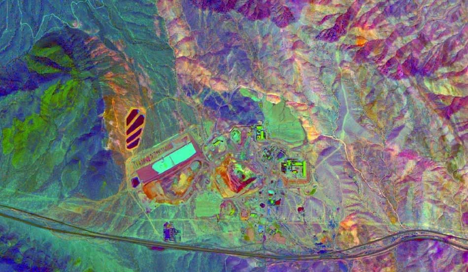
The operating principle of hyperspectral sensors allows analysts to differentiate minerals based on their unique spectral signatures. Each mineral exhibits a distinct spectral signature, measured under controlled laboratory conditions using spectrometers.
The following workflow shows how this type of imagery enables more effective mineral exploration:
A private company or governmental organization exploring for gold across a specific region can use known spectral signatures of alteration minerals commonly associated with gold systems.
Analysts who work for these organizations can use archival or recent hyperspectral imagery of that specific zone, then process it to detect where these signatures appear at the surface. These areas are more likely to host the gold mineralization the team is targeting.
After identifying some zones with high probability of matching mineral assemblages, support teams flag them as priority targets that field resources should inspect first and drill if evidence suggests they’re the most promising zones.
Exploration companies are among the primary beneficiaries of spatial data in their surveys. As explained above, satellite data enables the screening of large regions, early identification of high-potential targets, and reduced unnecessary fieldwork.
Note that in early-stage exploration, teams often struggle with limited budgets and constrained time. As a result, these efficiencies are particularly valuable. These insights are also helpful in advanced stages where accuracy is critical, and more focused drilling decisions can prevent unexpected issues.
In addition to these companies, public agencies can leverage satellite acquisitions to support regional geological mapping, resource assessment, and long-term mineral inventory programs. The wide-area, continuous coverage provided by satellite imagery enables systematic analysis across national or cross-border regions.
Ultimately, remote sensing consultancies also use satellite data to deliver mineral mapping, alteration analyses, and exploration targeting studies for their clients. By accessing various datasets, these companies can tailor their assessments to different commodities, terrains, and exploration objectives.
With LandEye, users can access hyperspectral and multispectral satellite data from multiple providers through a single interface. This centralized approach enables exploration and operational teams to compare options and quickly source the most suitable imagery, without engaging in separate vendor negotiations.
Analysts and decision-makers can aggregate data from different missions to obtain cost-effective coverage of vast and remote regions. As discussed, this supports early-stage regional screening alongside more targeted analysis. Note that with traditional methods, large-area exploration programs present multiple challenges, and spatial data helps reduce them.
Another key capability of LandEye is that imagery is delivered in formats compatible with common geological and remote sensing software, allowing teams to integrate satellite data directly into existing interpretation and analysis models. Furthermore, clear licensing terms and secure, escrow-based payments effectively lower procurement risk by improving transaction transparency.
Using satellite imagery enhances fieldwork efficiency in mineral exploration and mining by providing accurate, up-to-date data more efficiently. These insights enable early-stage screening, large-area analysis, and objective target identification, helping ground teams narrow their focus. The main benefits include reduced exploration uncertainty, more focused field efforts, and better-informed decisions.
With LandEye, the centralized marketplace for Earth imagery, teams can easily access both archival and newly acquired satellite imagery. This platform minimizes friction in data discovery and procurement. By connecting users to multiple providers and delivering analysis-ready datasets, LandEye supports more efficient, lower-risk exploration workflows from regional assessment to targeted drilling.
Case studies with similar tags.
Articles with similar tags.

